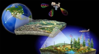
Course description

What will i learn?

Requirements

  • GIS Remote Sensing Spatial Analysis Satellite Imagery

Frequently asked question

Geographic Information Systems (GIS) and Remote Sensing play a crucial role in modern civil engineering by providing valuable spatial data and analysis tools. GIS is used for mapping, analyzing, and managing geographical data. It helps engineers visualize, interpret, and analyze spatial relationships and patterns within a specific area. GIS is commonly used for tasks like site selection, urban planning, infrastructure design, land-use management, and environmental impact assessments. It allows engineers to make data-driven decisions about the location and design of projects. Remote Sensing involves acquiring data from satellites, drones, or other aerial platforms to monitor and measure the Earth’s surface without direct contact. It provides information on topography, land cover, vegetation, water bodies, and more. Remote sensing helps with large-scale data collection, environmental monitoring, and disaster management. Engineers can use this data for mapping flood zones, assessing land degradation, or planning transportation networks.

TechZnanie Innoversity

TechZnanie Innoversity Pvt. Ltd. is India’s Employability Engine, bridging the gap between education and employment. We deliver placement-linked, project-based programs across Engineering, IT, and Management domains through a 2-month online + 1-month offline hybrid model. With AI-driven learning, real-world projects, and industry mentorship, we empower students from Tier I–III cities to transition seamlessly from campus to career.

₹21999

₹28999

Lectures

1

Skill level

Advanced

Expiry period

Lifetime

Share this course

Related courses